
BY DONOVAN QUINTERO
NAVAJO TIMES
WINDOW ROCK — Will the Navajo Nation have a white Christmas?
According to the National Oceanic and Atmospheric Administration, most of the reservation has a high probability of getting an inch of snow in the lower elevations, and more than an inch in the higher elevations.
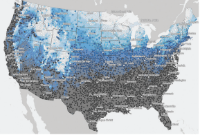
A map by the NOAA’s National Center for Environmental Information, which has been recording the history of how much snow is on the ground on Christmas Day since 1981, depicts most of the expected snow for the U.S. falling farther north. However, areas with higher terrain like the Chuska Mountains, Navajo Mountain, and the San Francisco Peaks have an even higher probability of receiving snow by Dec. 25 that will be greater than one-inch. In those places, you might want to clean the cobwebs off the sled.
While Christmas is still 10 days away, the National Weather Service is forecasting a brief snowstorm to roll through the area on Friday and Saturday.
Gusting winds up to more than 50 miles per hour are expected for portions of Eastern Agency in New Mexico, with several inches of snow expected to fall in the higher elevations beginning Friday.
On the Arizona side of the reservation, a slight chance of snow is predicted for Thursday and will increase by Friday. Higher terrain is forecasted to receive more snow.
Temperatures will plummet into the teens as the skies begin to clear by Sunday across the reservation. NOAA says the three-decades-long average measurements are based on the climate from about 9,800 stations operated by the National Weather Service across the country.
To date, according to the National Operational Hydrologic Remote Sensing Center, the Southwest region of the U.S., which includes Arizona, Utah, and New Mexico, has received an average of less than an inch of snow, with a maximum of a little over 47 inches in mountainous areas.
NAVAJO TIMES | DONOVAN QUINTERO
Darker areas on the map show where one inch of snow will less likely be, compared to lighter and blue areas, on Christmas Day, according to the National Oceanic and Atmospheric Administration.
NAVAJO TIMES | DONOVAN QUINTERO
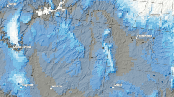
Blue areas across the Navajo Nation indicate a higher probability of one inch of snow being on the ground, according to the National Oceanic and Atmospheric Administration.